I pull into the Sawyer Road boat launch at the top of the New Meadows River in Brunswick ready for a full day trip around the islands of Harpswell.
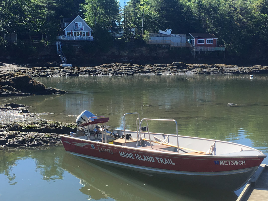
The first thing I see is the MITA boat on a small trailer pulled by a Subaru Outback. Of course it’s a Subaru Outback. The driver of the Outback is Mike Duffy, a retired trucker and part-time sea kayak guide for L.L. Bean from Falmouth. He is a skipper-in-training, learning the ropes of island monitoring. Mike backs his car up to the ramp and slides the MITA boat into the water. The boat, named Arcadia, is an eighteen foot dark red, aluminum Lund skiff with “Maine Island Trail Association” lettered on the side. The boat is equipped with a thirty horsepower Honda outboard motor and a spot at the stern for the skipper to hold the motor’s tiller, have a chart easily accessible, and look out at the route ahead. The middle of the boat has several seating and storage areas with a bar in the middle for holding and securing gear.
Finally, after a communication mix-up with other skippers, Chris Wall, the MITA regional stewardship manager for southern Maine, pulls up. He’s driving a silver Toyota RAV4 with a license plate reading “MITA” and a large MITA logo decal on the spare tire case. No doubt I’m in the right place.
The Maine Island Trail Association efforts include stewardship, conservation, and respectful recreational use of more than 200 islands spanning 375 miles from Kittery to maritime Canada. One-third of the sites each are owned by the state, private individuals, and organizations such as land trusts. They have a crew of about thirty volunteers, mostly retired white men, who routinely check up on sites throughout the summer. They promote Leave No Trace and particularly leave no waste practices allowing members to use the islands without a fee or reservation. Over the years, MITA has developed a positive peer pressure culture of “we respect the islands, and you should too.”
The islands are fragile and in need of respect. In the past, the islands saw much more abuse from visitors through litter, graffiti, erosion, and intense camping and fire impact. People used to chop down trees all along the coast without recognizing how hard it is for new trees to grow in the harsh environment. Many people don’t understand that the mere six inches of soil atop the island bedrock is very little. Now, sites on the Maine Island Trail receive stewardship in the form of trail maintenance, trash removal, and education of the public.
It is low tide when we start, which means that we will go around Harpswell clockwise. This is because Long Reach and Ewing Narrows to the west are virtually inaccessible at low tide. If we start headed south down the New Meadows River in the east, by the time we head up north in the west, the tide will be high enough to easily pass through the narrow reaches.
We load up our lunches, loppers, a chainsaw, and garbage bags then head out down the New Meadows River. The land on either side is Brunswick and Bath for awhile, before the water opens up a little and Brunswick gives way to Sebascodegan Island. Mike is at the helm, holding the Honda’s tiller as we cruise through a thin channel of seaside houses with docks and recreational motor boats.
The glassy water is a canvas of reflection with swathes of blue, green, and brown only broken by the Lund’s bow gently slicing through. The motor is a constant and soft hum with a light gurgle from disturbed water below. A tern flaps pasts us then dive bombs, seeking breakfast. Across the river, a fish jumps out of the water, taunting the hungry birds. A family of Canadian geese glide by with young growing faster than their duckling feathers can keep up with. On a mudflat, two great blue herons stalk along the water’s edge. One takes off, huge gray wings flowing magnificently as its straw-like legs follow behind.
In a particularly narrow spot, a white cylindrical buoy bobs with orange stripes and “Slow No Wake” scrawled in shaky Sharpie.
When the land opens up, we speed up. There is now a constant breeze and our bow sloshes against the ripples. We leave a small v-shaped wake with perpetual white foam rolling off the edge. As we wind down the New Meadows River, we check on Merritt Island which is owned by Bowdoin College. There, we cut some trees and branches, clearing the three trails and pick up trash. The trash includes three meter-long escaped plastic dock floats. Trash in tow, we move on to our first stop in Harpswell.
Long Island is, well, a long island located just off Sebascodegan Island’s eastern shore. There is a campsite on the northern end, and the owners spend the summer next door. They have very friendly dogs and sometimes bring fresh food to visitors. While chatting, the owner couldn’t remember which MITA volunteer had come by recently. Chris prompted him to describe the volunteer’s beard as apparently you can easily distinguish MITA volunteers by the length of their beards.
We leave Long Island behind, heading down the side of Sebascodegan Island toward Cundy’s Harbor. Mike picks up the pace to match the strengthening wind. We leave behind a snake of flat white and blue striped water resembling classic toothpaste stripes. The waves ahead vary from calm to small and choppy.
Cundy’s Harbor is normally a bustling fishing harbor, but on a Wednesday, most fishermen take the day off leaving calm waters. Houses on the water north of Cundy’s Harbor sit on stilts with long piers extending out to steep ramps and floating docks. The wharves in town are piled high with yellow metal lobster cages of fishermen preparing to set their traps for the season.
A sloop glides in the distance with tall white sails full in the summer sun. It is the great heron among boats.
I’m lost in the sailboat’s majesty when I snap to the reality of our collision course. A lobster boat’s bow is aimed straight at us, ready to crush our little skiff in its path. Mike makes a subtle, but definite move to the starboard. The other boat moves in the same direction. We’re playing chicken for a split second but that boat is bigger and badder and has the right of way. Mike makes the evasive move to the port and we pass by each other, three people waving in each direction.
We catch up to the sloop. Its white sails are striking against the deep green island behind.
As we pass Cundy’s Harbor, the water opens up, and we can finally see the ocean horizon dotted with islands. Every few seconds, our bow drops off the crest of a wave, and my heart drops a little too. At the tip of Fort Point, we pass green can number 1, which is a large flashing buoy marking the mouth of the New Meadows River. As it bobs, you can see the barnacles and seaweed that live below the waterline. Passing north up toward Cundy’s Harbor is Whisky Girl. She’s a small boat with two guys on board. One is driving the boat and wearing orange waterproof overalls while the other is sunbathing on the back deck wearing jeans and a t-shirt. We cross their wake with a slap and a splash then continue around Cundy Point and past Yarmouth Island.
Our next stop is Raspberry Island just to the west of Yarmouth Island. We stop and eat lunch on a shoreline rock outcrop at the northern end looking up into Quahog Bay. As the tide rises, we see water spilling past us into the bay on both sides. There is a strip of rockweed floating directly off the tip of the island where the flowing water meets in the middle. While we’re eating, a large blue fishing boat named Ruth & Pat heads out to sea. Then it comes back. Then it heads back out again. Maybe someone forgot their lunch.
We then hop back in the boat and continue up Quahog Bay into the middle of the horseshoe of Sebascodegan Island. The lobster buoys are scattered everywhere, generally about thirty feet apart. There are channels and lanes of buoys. Maybe the buoys are all where the better rocks are. Or maybe the buoys are pushed out of lanes by boats passing through. Travelling through them is a slow motion slalom. You can get lost in the journey like a first person video game with dozens of tiny obstacles constantly coming your way.
We finally arrive at Little Snow Island, MITA’s highest priority island in the east Casco Bay area. Little Snow is a state owned island with three different sites. The island is long, thin, and flat with mostly deciduous trees and some shrubs and grasses. Chris said that within twenty years it will be two islands due to sea level rise. That is an extremely likely future given that the Gulf of Maine is one of the fastest warming places on earth.
Little Snow is the fourth most heavily used island of all MITA sites. There we found several firework casings in the fire ring and a partially burned particle board table. The visitors must have been drunk enough to think it would be a good idea to burn a chemical-laden table and too drunk to bring the rest of the table back off the island with them. There have also been complaints by neighbors about high levels E. coli, a sewage chemical tracer, in the water due to improper waste disposal on the island. Chris’s counter to that is the fact that volunteer monitors have only reported waste on the island four times in fifteen years while there are houses and boats all around, some of which may illegally dump waste. We pick up all the plastic we can find then head back down Quahog Bay and continue our journey west.
We weave between Long and Gun Points and the islands off their tips. Off the tip of one of the points is an island with one house on it. It is the perfect distance from shore to have power lines but not far enough away to be worth burying them. Therefore, there is one telephone pole on the tip of of the mainland with wires sagging down on their way to another pole just on the edge of the island. The wires hang about fifteen feet in the air at mid tide so we could pass underneath.
Down by the southern tips of Sebascodegan, we face a steadier wind and as a result receive more splash. The bow sends a spray with a momentary rainbow, some of it kissing my face. Ahead is one menacingly dark cloud while the rest of the sky remains blue with bright white puffy clouds. We pass under the dark cloud, and I can’t tell if the splash on my face is sea spray or raindrops. While turning past Gun Point, the bow slaps down on a wave hard, and the bow anchor clacks loudly against the deck. Rain streaks the sky over the next bay to the west.
We continue north into Gun Point Cove, now with Sebascodegan on our right and Orr’s Island on our left. It is now about high tide and we head inland with following seas coming from the open ocean to pass us from the stern. The water reflects the alternating white and blue of the sky above. We then approach the Orr’s Island bridge and cross below the road. Route 24 cuts through Orr’s Island like a reverse mohawk.
Harpswell Hideaway is our final stop of the day. These sites are on the west side of Sebascodegan Island near the Ewing Narrows bridge at the top of Harpswell Sound. Harpswell Hideaway is one of the few mainland sites on the Maine Island Trail. Just before arriving, we fall victim to the sheets of rain falling nearby.
As we rush to don rainjackets, Chris explains our situation by citing a big red dot directly over us on his phone radar app. Large raindrops patter hard against the water, the boat, and our bodies. Each drop feels and sounds like hail. The drops hitting the water slam the surface forming an instant ring before becoming part of the seawater. Looking south, you can see a mist rising off the water backlit by sun and blue sky not too far off. You can see through a thick curtain of downpour all the way down to Bailey Island and the large marker monument off its base.
We dock and climb out onto Harpswell Hideaway. Under the cover of trees, Chris tells us about the property. In fact, he’s not quite sure, but it may have recently been sold. The owner of the property is eccentric to say the least. A few years ago, the neighbor saw the owner and said, “Margie, I thought you were dead! And I thought the property was sold!” Well, neither of those were true at the time, but Chris isn’t sure about the current state of the owner or the property.
After a fifteen minute shower, the storm passes, and it’s sunny again.
Mike says, “You know what they say about Maine. Wait five minutes and the weather will change.”
It is then time to head home through Ewing Narrows and Long Reach which will have enough water now that the tide has risen. We pass under the Ewing Narrows Bridge between Sebscodegan Island and Harpswell Neck into more protected flat water.
We wind our way between Doughty Point on Sebascodegan and Prince Point on the mainland then enter into Long Reach. Aside from looking at a map, anyone would think that Long Reach is a lake. Especially at high tide with all the rocky seaweed covered, it looks like a beautiful long and skinny lake. We pass all the way to the north where we follow a narrow maze, go under the Route 24 bridge to the mainland and finally return to the New Meadows River. We pass the handwritten “Slow No Wake” buoy and know we have completed a full lap of Harpswell.
After a day in the sun, the steady buzz of the motor and rhythmic slosh of water off the boat’s sides draws my eyes closed. Nothing else matters but the breeze wavering in my ears and its soft brush against my cheeks.
Thanks for joining me on a trip around all the islands.
The next page has some of my thoughts about the land and water of Harpswell.
The next page has some of my thoughts about the land and water of Harpswell.
